
Proposed waterfowl zones for the 2016-2021 seasons. Proposed changes to the waterfowl hunting zones are available for public comment through Nov. 5.
New waterfowl hunting zones taken into consideration
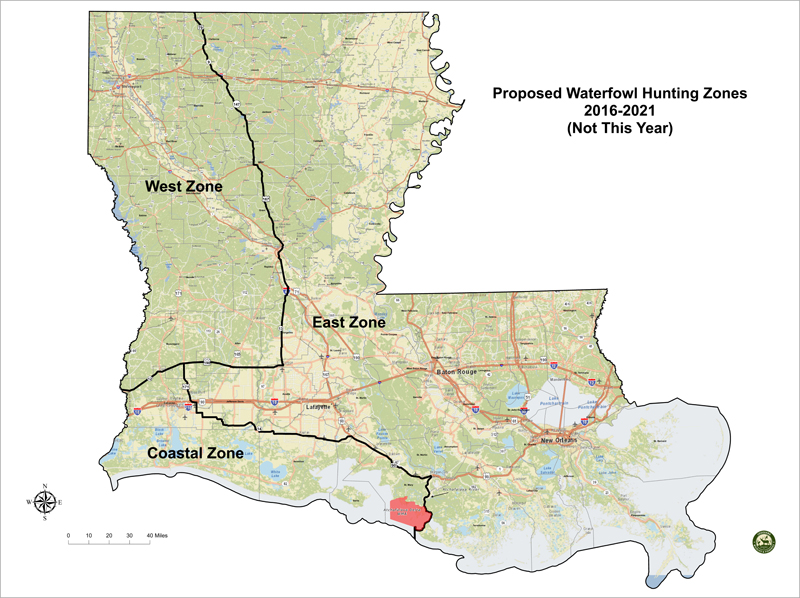
Possible changes to the state's three waterfowl hunting zones could place almost all of St. Landry Parish in the East Zone for the 2016-2021 seasons, and the change would go into effect during next year's fall hunting seasons.
Proposed changes to the waterfowl hunting zones are available for public comment through Nov. 5. The Louisiana Department of Wildlife and Fisheries is requesting comments be sent to Larry Reynolds, Waterfowl Program Manager, lreynolds@wlf.la.gov by Oct. 30, but additional comment can be provided directly to the Commission at the Nov. 5, meeting in Baton Rouge. Public comment received by Oct. 30 on the proposed waterfowl hunting zone changes will be summarized and presented to the Commission at their Nov. 5 meeting. Waterfowl hunting zones approved by the Commission in November would take effect in the 2016-17 waterfowl hunting season and remain in place for five years.
The department presented a revised waterfowl hunting zone map to the public that would be considered for the 2016-21 waterfowl hunting seasons during the during the Oct. 1 Louisiana Wildlife and Fisheries Commission meeting.
Zones for waterfowl hunting can be changed every five years, and this opportunity comes at the same time the review/approval process for setting waterfowl hunting regulations is being moved to an earlier time frame in the calendar year.
Consequently, changes to waterfowl hunting zones must be decided prior to December 1, 2015 to take effect for the 2016-17 hunting season.
Department Wildlife Division staff received comments and suggestions on waterfowl hunting zone changes from waterfowl hunters at public meetings conducted in September. The major changes conferred by the proposed new zones include moving the marshes of southeast Louisiana from the Coastal into the East Zone; moving a large amount of rice-growing acreage in Evangeline, Jefferson Davis, Acadia, and Vermilion parishes from the Coastal to the East Zone; and moving a portion of northwest Louisiana from the East Zone to the West Zone.
The new proposed boundaries are:
East Zone: The area of the state between the Mississippi State line and the line going south on Hwy. 79 from the Arkansas border to Homer; then south on Hwy. 9 to Arcadia; then south on Hwy. 147 to Hodge; then south on Hwy. 167 to Turkey Creek; then south on Hwy. 13 to Eunice; then west on Hwy. 190 to its junction with Hwy. 171 at Ragley; then south on Hwy. 171 to Lake Charles; then south and east on Hwy. 14 to its junction with Hwy. 90 in New Iberia; then east on Hwy. 90 to its junction with the Atchafalaya River; then south along the east bank of the Atchafalaya River to the boundary of Atchafalaya Delta WMA; then along the eastern boundary of the Atchafalaya Delta WMA to the end of Point au Fer Island ; then due south to the end of state waters.
West Zone: The area between the Texas State line and the line going east on Hwy. 190/12 to Eunice; then north on Hwy. 13 to Turkey Creek; then north on Hwy. 167 to Hodge; then north on Hwy. 147 to Arcadia; then north on Hwy. 9 to Homer; then north on Hwy. 79 to the Arkansas border.
Coastal Zone: Remainder of state.
- Log in to post comments